
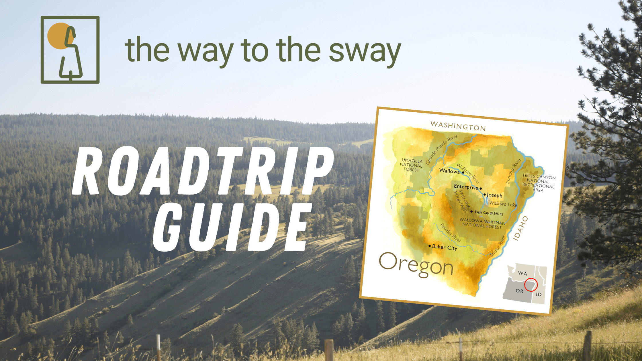
The countdown is officially on—only a few months until we gather under the trees!
While we can't wait to see everyone at the Summer Sway, the adventure truly begins the moment you hit the road. Northeastern Oregon is a land of vast canyons, alpine lakes, and rugged history. As you map out your route to the ranch, remember that some of the best memories are made in the "in-between" places.
Whether you’re looking for a legendary wood-fired pizza, a quiet riverside campsite, or a white-knuckle drive down a canyon grade, we’ve rounded up our favorite hidden gems to check out on your way to (or from) the ranch.
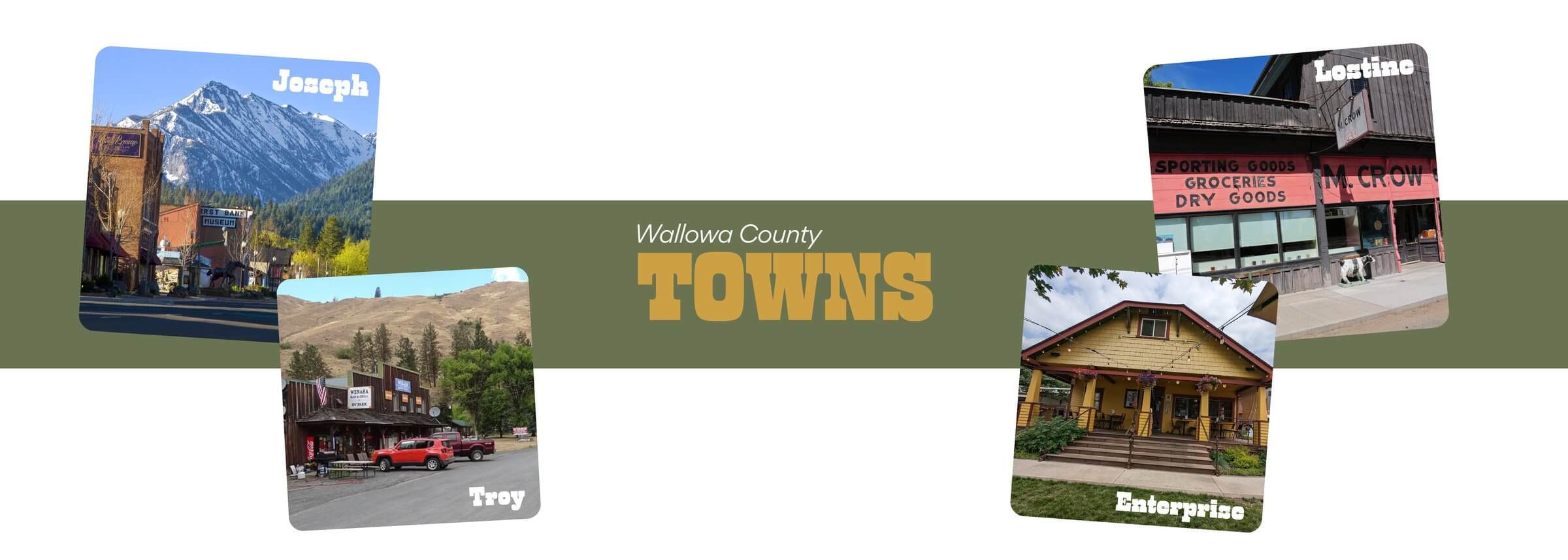
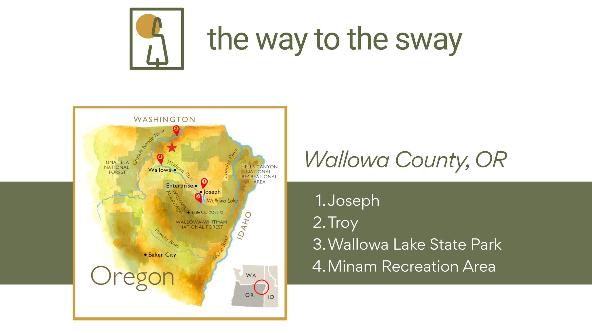
Joseph, Oregon
- Map:Get Directions
- Distance from Ranch: ~1 hour 30 minutes
- What it is: Joseph is named after Chief Joseph, the respected leader of the Nez Perce people. The town sits in an area long inhabited by the Nez Perce, and the name reflects that history and connection to the land. Today, Joseph blends that deeper cultural past with a relaxed mountain-town feel.
- What to do: Explore local shops, galleries, and cafés on the main street. It offers easy access to Wallowa Lake, framed by the stunning Wallowa Mountains. It’s the perfect spot to grab a coffee or a souvenir before heading up to the ranch.
Troy, Oregon
- Map:Get Directions
- Distance from Ranch: ~1 hour
- What it is: Troy is a tiny, laid-back outpost sitting right on the Grande Ronde River. It has a small store and a bar—just enough to round out a solid day on the water.
- What to do: The Grande Ronde River here is a well-known fishing stretch with clear water, deep runs, and long riffles that hold trout and smallmouth bass. You can wade or fish right from the bank. On warmer days, this stretch doubles as an easy inner-tube float from the bridge into town.
Lostine, Oregon
- Map:Get Directions
- Distance from Ranch: ~1 hour
- What it is: Don’t blink or you might miss it, but Lostine is arguably the "coolest" tiny town in the county. It feels like a time capsule that has been stylishly reinvented.
- What to do: M. Crow & Company is a must-stop. It is a 100-year-old general store that has been revitalized by a high-end designer. They sell everything from handmade ceramics and axes to fresh groceries, but the real draw is the wood-fired pizza in the back. It’s an incredible mix of old-school Oregon and modern design.
Enterprise, Oregon
- Map:Get Directions
- Distance from Ranch: ~1 hour 15 minutes
- What it is: The county seat and the "hub" of the valley. It’s less touristy than Joseph but has a very authentic, working-town vibe with some of the best food and drink in the area.
• What to do: Go to Terminal Gravity Brewing. It is an iconic PNW brewery with a fantastic outdoor yard, picnic tables, and willow trees. It’s the perfect place to sit outside, eat a burger, and have a pint of their famous IPA before you head off the grid.
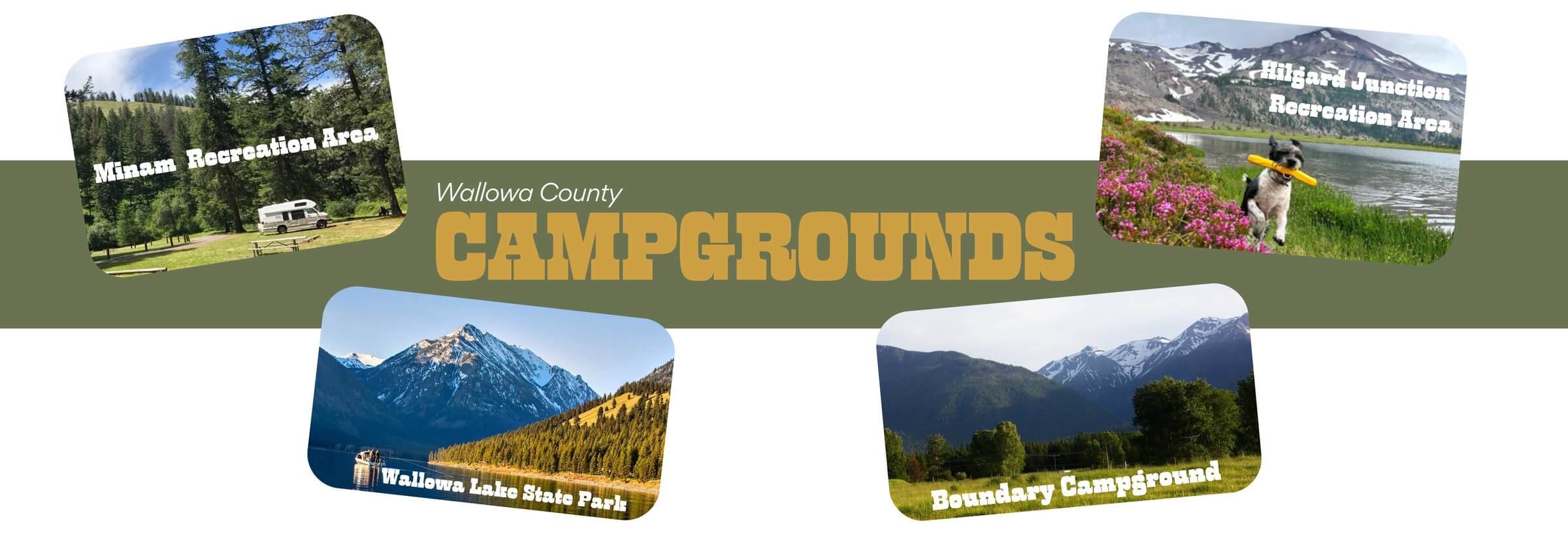
Minam State Recreation Area
- Map:Get Directions
- Distance from Ranch: ~1 hour
- What it is: A quiet, scenic stop sitting right along the Grande Ronde River. It offers shaded riverside campsites with simple amenities.
- What to do: Great for fishing and swimming. It’s the perfect spot if you want a low-key night by the water before or after your stay at the ranch.
- Info:
- Cost: $10
- Website:Oregon State Parks - Minam
Wallowa Lake State Park
- Map:Get Directions
- Distance from Ranch: ~1 hour 30 minutes
- What it is: Classic Oregon camping right at the base of the Wallowa Mountains. It has that iconic alpine-meets-lake feel with big views and cool evenings.
- What to do: Campsites range from tent to RV and sit close to the lake with easy access to swimming, paddling, fishing, and shoreline walks.
- Info:
- Reservations: 800-452-5687 (July fills up fast; reservations typically necessary).
- Website:Oregon State Parks - Wallowa Lake
Boundary Campground
- Map:Get Directions
- Distance from Ranch: ~1 hour 15 minutes (via Wallowa)
- What it is: A free, first-come, first-served Forest Service campground tucked away in the Bear Creek area. It is much more secluded than the state parks.
- What to do: This is a "dry camping" spot (no water hookups, vault toilets only), perfect for those who want a quiet night in the timber. It sits right on the edge of the forest boundary, offering a true off-grid feel.
- Info:
- Cost: Free
- Note: The road turns to gravel, so take it slow.
Hilgard Junction State Recreation Area
- Map:Get Directions
- Distance from Ranch: ~1 hour 50 minutes
- What it is: Located right off I-84 near La Grande, this is a convenient shaded campground along the Grande Ronde River. It’s famous for its cottonwood trees that turn brilliant gold in the summer/fall.
- What to do: It’s a rafter’s paradise and a great spot to dip your toes in the water after a long drive.
- Info:
- Reservations: This park is currently a first come first serve campground. You must be physically at the park to get an empty site. At this time, you can't reserve sites for camping.
- Website:Oregon State Parks - Hilgard Junction
Red Bridge State Wayside
- Map:Get Directions
- Distance from Ranch: ~2 hours
- What it is: A lush, green park sitting right on the river. It feels manicured and well-kept, with plenty of shade and level ground for tents.
- What to do: It’s an excellent spot for a picnic or an overnight stay. The river here is calm and accessible, making it great for wading or fly fishing.
- Info:
- Reservations: This park is currently a first come first serve campground. You must be physically at the park to get an empty site. At this time, you can't reserve sites for camping.
- Website:Oregon State Parks - Red Bridge
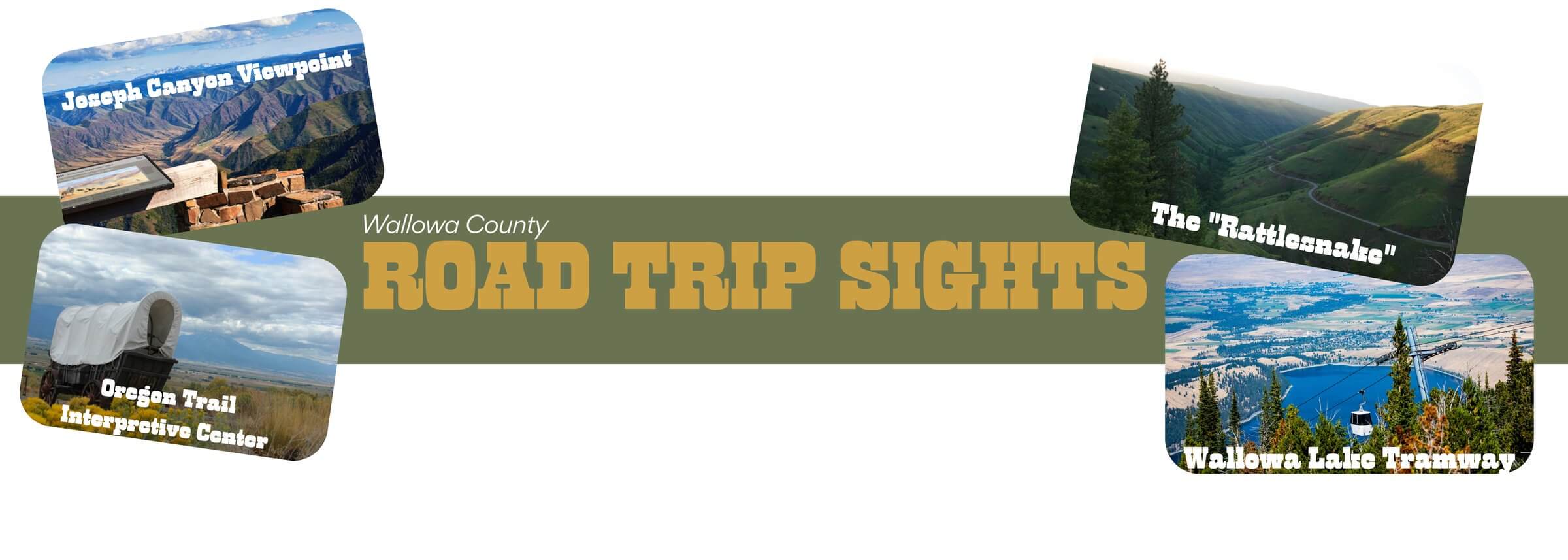
Joseph Canyon Viewpoint
- Map:Get Directions
- Distance from Ranch: ~1h 40 minutes
- What it is: A stunning paved overlook that offers a massive view of Joseph Canyon and Joseph Creek. This area was the winter home of the Chief Joseph band of the Nez Perce tribe for centuries.
- What to do: Pull over! It is one of the easiest, high-reward views in the county. There are interpretive signs about the Nez Perce history and geology. It’s the best place to get a sense of the scale of the landscape you are camping in.
The Flora School
- Map:Get Directions
- Distance from Ranch: ~1 hour 30 minutes
- What it is: A historic schoolhouse built in 1915 located in the near-ghost town of Flora. It is a stunning piece of pioneer architecture that has been restored as an education center.
- What to do: Stop for a quick photo op of the "most impressive schoolhouse in the West" and see a piece of local history right around the corner from the event. It’s a great example of the homesteading spirit of the area.
Wallowa Lake Tramway
- Map:Get Directions
- Distance from Ranch: ~1 hour 30 minutes
- What it is: The steepest vertical lift for a 4-passenger gondola in North America. It takes you from the lake floor up to the top of Mt. Howard (8,150 ft).
- What to do: Ride the gondola up for incredible panoramic views of the Wallowa Mountains and the Eagle Cap Wilderness. There are walking trails and a summit grill at the top—perfect for lunch with a view. Website: https://wallowalaketram.com
The "Rattlesnake" (Highway 3 Grade)
- Map:Get Directions
- Distance from Ranch: ~1h 40 minutes
- What it is: Just north of Flora, the highway drops 2,000 feet into the Grande Ronde river canyon in a series of dizzying switchbacks. It is famous among motorcyclists and drivers as one of the most thrilling roads in the Northwest.
- What to do: If you enjoy a "spirited drive," head north from the ranch. The road twists down to the river where you can grab a milkshake at Boggan’s Oasis (a classic roadside stop) before turning around. The views of the layered canyon walls are incredible.
National Historic Oregon Trail Interpretive Center
- Map:Get Directions
- Distance from Ranch: ~2 hours 30 minutes
- What it is: Located on the windswept Flagstaff Hill, this is one of the premier Oregon Trail sites in the country. It offers living history demonstrations, interactive exhibits, and actual wagon ruts carved into the earth by pioneers.
- What to do: Stretch your legs on the paved trails around the center. It’s a great way to connect with the history of the wagons that traveled this exact route over 150 years ago before you arrive at the ranch.
Hells Canyon Overlook
- Map:Get Directions
- Distance from Ranch: ~3 hours 30 minutes (Scenic Route)
- What it is: A paved overlook that offers a jaw-dropping view into Hells Canyon, the deepest river gorge in North America (yes, deeper than the Grand Canyon).
• What to do: If you are coming from the south or have extra time for a scenic drive, this loop is unbeatable. You can see the Seven Devils Mountains of Idaho across the gorge. It’s a bit of a drive, but the scale of the canyon is humbling.
Northeastern Oregon is more than just a backdrop—it’s a place that rewards those who take the long way around. We hope these stops help you make the most of your journey into Wallowa County.
Take your time, enjoy the views, and drive safe. We’ll have the campfires ready and the trees waiting for your arrival.
Derek and Crew


Comments (0)
No comments yet — be the first!
Leave a Comment